Map
Collection object
1990.0158
Frame H. 107.2 W. 143.9
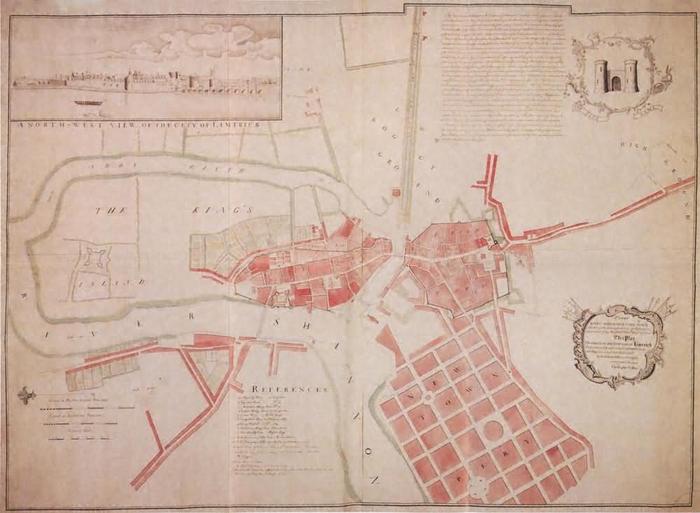
Map, "Plan of the city and suburbs of Limerick", by Christopher Colles 1769. Colour photograph of. Map with east to top showing Island Field, Englishtown, Thomondgate, Irishtown and Newtownpery as originally planned rather than as built. Colours; red, yellow, green and blue. Title in cartouche at bottom right reads "To the/ Right Honourable Earl Percy/ Member of Parliament for the City of Westminster/ and Colonel of his Majesty's 5th Regmt. of Foot./ This Plan of the City and Suburbs of Limerick/ Undertaken and finish'd at his Lordship's desire/ and Expence [sic] is most humbly Insrib'd./ By his Lordship's much obliged and devoted servant/ Christopher Colles." At top left is an inset view titled "A North-West View of the City of Limerick"; taken from the west bank of the Shannon, shows from just north of Island Gate to almost the full span of Thomond Bridge, with the Castle, St. Mary's and Custom's House behind the bridge. At top left in a cartouche are the arms of Limerick, a castle gate, but without the dome or conical roof normally found between the two; below on scroll "The City Arms". To left of arms is a short history of Limerick. At centre bottom is a key titled "References". At bottom left a North arrow, with below three scales "Plantation Perches", "Statute perches" and "Feet". The foot scale is nine sixteenths of an inch to one hundred foot. Photographed on four large sheets, ?A2, joined together. Black frame with gold internal edge.
Christopher Colles (surveyor)