Map
Collection object
1987.0162.07
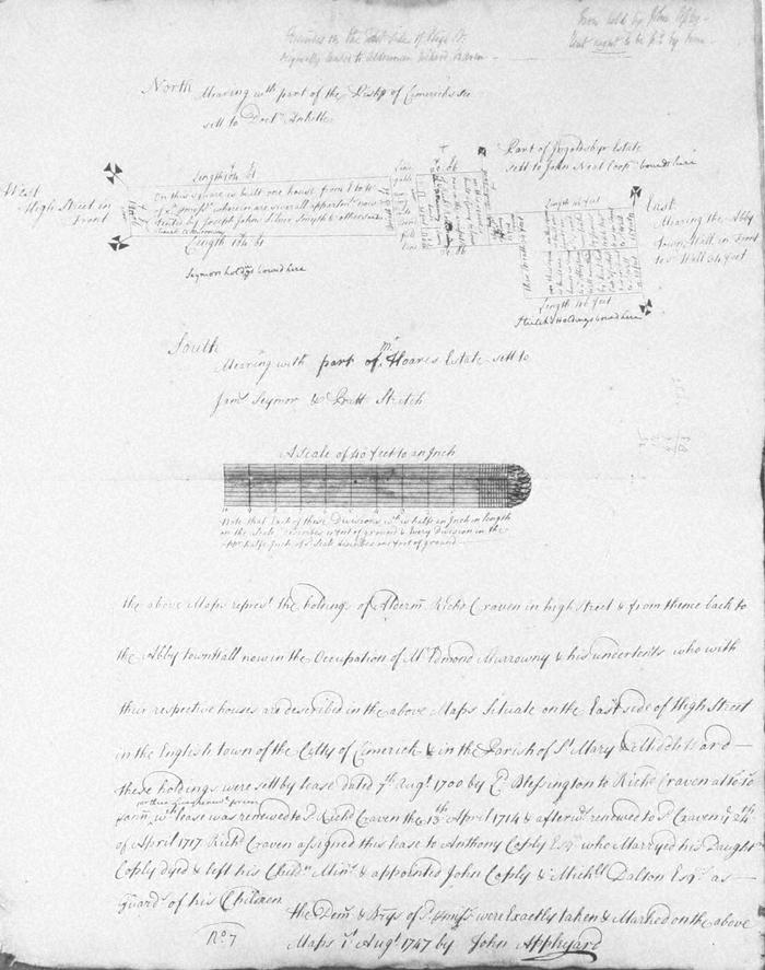
Map, photograph of, from set of estate of Edward Hoare in the city of Limerick by John Appleyard, 1747. No. 7. Premises fronting E side of High Street, backing onto Bonfields Lane, continuing on E side of this lane to within 34ft. of Abbey town wall, St Mary's parish, Englishtown. 1 August 1747. Alderman Richard Craven's holding occupied by Edmond Murrowny (Moroney), set in 1700 by Lord Blessington to Richard Craven, renewed twice and assigned to Anthony Coply who married his daughter and when he died John Coply and Michael Dalton acted as guardians of his children. Mearing on the south with part of Mr Hoare's estate set to James Seymour and Batt Stritch; on east with abbey town wall, on west with HighStreet and on north Bishop of Limerick's land set to Doctor Anketle. Joseph Johns, silversmith, at front of property with undertenants to Murrowny (Moroney. To east of lane a linny (OED, shed with lean to roof) and house occupied by Richard Roberts, undertenant to Murrowny; also houseof Paul Rock, ships captain and house of James White tailor. Note at top right that sold by John Coply and that rent ought to be paid by Bain.
(see also Limerick City Archive; Series 2: Volume 1: P23/ 25-47, 1874-1908 File 10: Particulars and Conditions of Sale by Auction of the Hoare Estate, including property in Mungret Street, Mary Street, Bridge Street, Nicholas Street, Castle Street, The Crescent and Henry Street, Limerick; includes hand coloured maps by R. Fogerty. William B. Fitt Auctioneers., 27 February 1903 )
(see also Limerick City Archive; Series 2: Volume 1: P23/ 25-47, 1874-1908 File 10: Particulars and Conditions of Sale by Auction of the Hoare Estate, including property in Mungret Street, Mary Street, Bridge Street, Nicholas Street, Castle Street, The Crescent and Henry Street, Limerick; includes hand coloured maps by R. Fogerty. William B. Fitt Auctioneers., 27 February 1903 )
John Appleyard (surveyor)