Map
Collection object
1987.0162.05
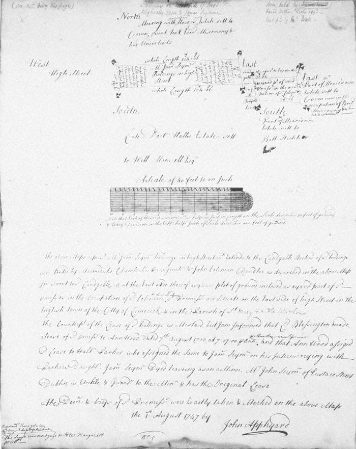
Map, photograph of, from set of estate of Edward Hoare in the city of Limerick by John Appleyard, 1747. No. 4. Premises fronting W side of High Street, St Mary's parish, Englishtown, backing onto town wall, a lane between town wall and premises. 1 August 1747. James Seymous holding, now tenanted by Marmaduke Chamberlin, periwigmaker, and John Coleman, chandler. Set by Lord Blessington in 1700 to Ann Wood, who assigned the lease to Walter Parker who assigned it to James Seymour on marrying Parker's daughter. Seymour died leaving son under guardianship of his uncle John Seymour of Eustace Street, Dublin.Mearing mearing on west with High St; north with Hoare's own estate set to Craven present tenant Edmond Murrowney (Moroney) and his undertenants; on east as north; on south with the late Dr Hall's estate set to William Monsell on western part and on east with Hoares own esate set to Batt Stritch. In pencil attop right, now held by David Arthur Leahy, rent paid by McHale. At botom left note that lease mortgaged to Peter Margarett
(see also Limerick City Archive; Series 2: Volume 1: P23/ 25-47, 1874-1908 File 10: Particulars and Conditions of Sale by Auction of the Hoare Estate, including property in Mungret Street, Mary Street, Bridge Street, Nicholas Street, Castle Street, The Crescent and Henry Street, Limerick; includes hand coloured maps by R. Fogerty. William B. Fitt Auctioneers., 27 February 1903 )
(see also Limerick City Archive; Series 2: Volume 1: P23/ 25-47, 1874-1908 File 10: Particulars and Conditions of Sale by Auction of the Hoare Estate, including property in Mungret Street, Mary Street, Bridge Street, Nicholas Street, Castle Street, The Crescent and Henry Street, Limerick; includes hand coloured maps by R. Fogerty. William B. Fitt Auctioneers., 27 February 1903 )
John Appleyard (surveyor)