Map
Collection object
1987.0162.04
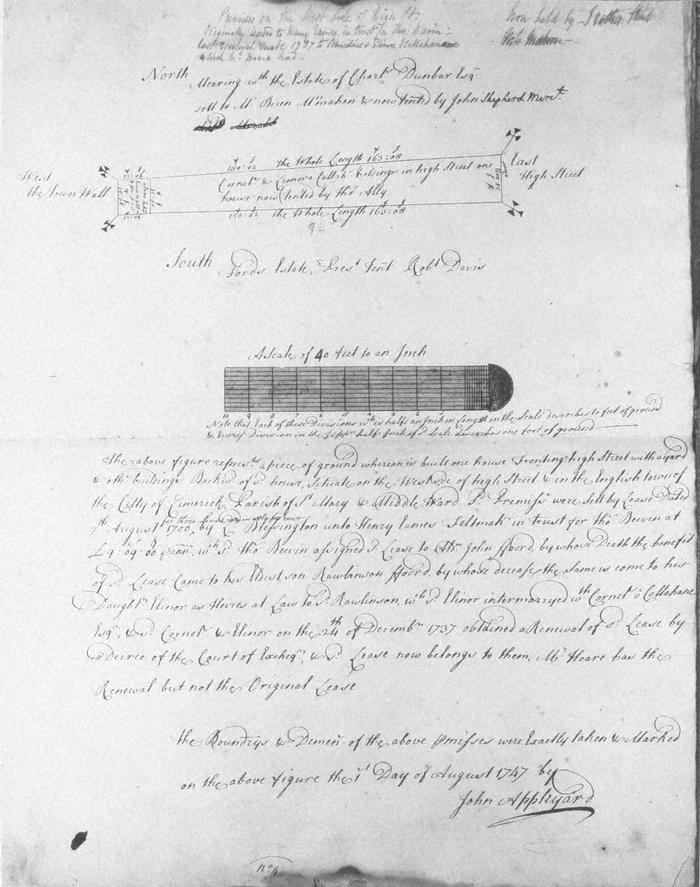
Map, photograph of, from set of estate of Edward Hoare in the city of Limerick by John Appleyard, 1747. No. 4. Premises fronting W side of High Street, St Mary's parish, Englishtown, backing onto town wall, a lane between town wall and premises. 1 August 1747. Premises set by Lord Blessington in 1700, to Henry Eames Feltmaker in trust for Thomas Bewin(?); lease assigned to Alderman John Fforde then came to his son Rawlinson then to Rawlinsons daughter Elinor who married Cornelius O Callahane (O'Callaghan). North mearing with estate of Charles Dunbar set to Brian McMahon and noew tenanted by John Shepherd, merchant; on east with High Street; on west with city wall, on south with Ford's estate tenanted by Robert Davis. Pencil not at top right, Now held by, I rather think, McMahon
(see also Limerick City Archive; Series 2: Volume 1: P23/ 25-47, 1874-1908 File 10: Particulars and Conditions of Sale by Auction of the Hoare Estate, including property in Mungret Street, Mary Street, Bridge Street, Nicholas Street, Castle Street, The Crescent and Henry Street, Limerick; includes hand coloured maps by R. Fogerty. William B. Fitt Auctioneers., 27 February 1903 )
(see also Limerick City Archive; Series 2: Volume 1: P23/ 25-47, 1874-1908 File 10: Particulars and Conditions of Sale by Auction of the Hoare Estate, including property in Mungret Street, Mary Street, Bridge Street, Nicholas Street, Castle Street, The Crescent and Henry Street, Limerick; includes hand coloured maps by R. Fogerty. William B. Fitt Auctioneers., 27 February 1903 )
John Appleyard (surveyor)