Map
Collection object
1987.0162.02
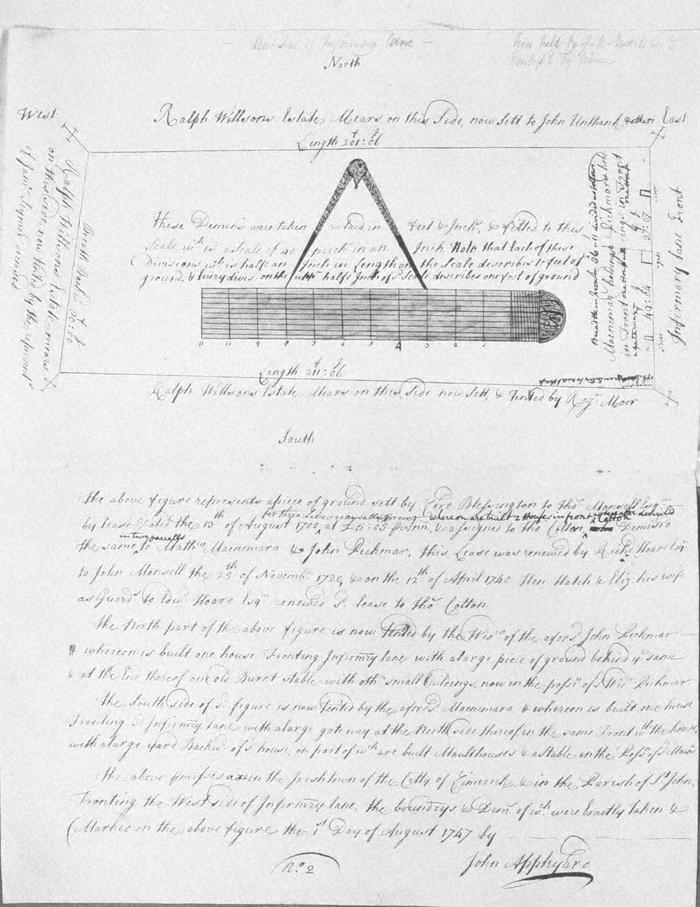
Map, photograph of, from set of estate of Edward Hoare in the city of Limerick by John Appleyard, 1747. No. 2. Premises fronting W side of Infirmary Lane, in Irishtown. 1 August 1747. Ground sett by Lord Blessington to Thomas Monsell by lease of 13 August 1700, assigned to Thomas Cotton, demised in two parcels to Matthew Macnamara and John Pickman; lease renewed by Richard Hoare to John Monsell in 1720 and in 1740 by Henry Hatch and his wife Elizabeth guardians of Edward Hoare, to Thomas Cotton. One part now tenanted by Widow Pickman, who has a house and burnt out stable. The other held by Macnamara has a house, malthouse and stable. West side mears with estate of Ralph Wilson tenanted by the reps. of James Seymour deceased; south with Wilson estate tenanted by Roger Moor; on east with Infirmary Lane; on north with Wilson estate set to John Unthank and others. In pencil at top Now held by John Russell
(see also Limerick City Archive; Series 2: Volume 1: P23/ 25-47, 1874-1908 File 10: Particulars and Conditions of Sale by Auction of the Hoare Estate, including property in Mungret Street, Mary Street, Bridge Street, Nicholas Street, Castle Street, The Crescent and Henry Street, Limerick; includes hand coloured maps by R. Fogerty. William B. Fitt Auctioneers., 27 February 1903 )
(see also Limerick City Archive; Series 2: Volume 1: P23/ 25-47, 1874-1908 File 10: Particulars and Conditions of Sale by Auction of the Hoare Estate, including property in Mungret Street, Mary Street, Bridge Street, Nicholas Street, Castle Street, The Crescent and Henry Street, Limerick; includes hand coloured maps by R. Fogerty. William B. Fitt Auctioneers., 27 February 1903 )
John Appleyard (surveyor)