Map
Collection object
1987.0162.17
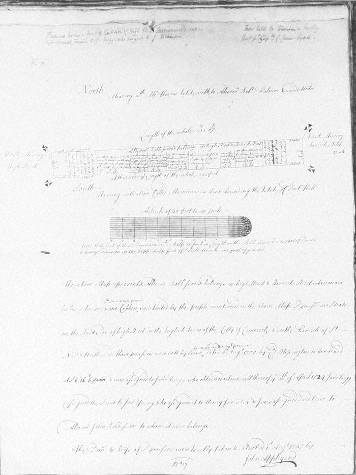
Map, photograph of, from set of estate of Edward Hoare in the city of Limerick by John Appleyard, 1747. No. 17. Premises fronting onto E side of High Street, bounded on the E by Barrack Street, on the S by MacNamaras Lane bounding the estate of Dr Hall, and by Hoare estate on N; in St Nicholas' parish. 1 August 1747. Alderman Robbissons (Robinson?) holding, set in 1700 by Lord Blessington to ann Wood , assigned to James Twigg who assigned it to Joseph Yopung who assigned it to Henry Ivers who assigned it to Robbisson. High street end has house and workhouse of Nathaniel Merritt, chandler; William Grifin, carpenter, holds a house and cabin, John McMahon, Philip Connell and David Mahony other house owners. pencil note that now held by Robinson and Mackey and rent paid by Reps of James Lynch
(see also Limerick City Archive; Series 2: Volume 1: P23/ 25-47, 1874-1908 File 10: Particulars and Conditions of Sale by Auction of the Hoare Estate, including property in Mungret Street, Mary Street, Bridge Street, Nicholas Street, Castle Street, The Crescent and Henry Street, Limerick; includes hand coloured maps by R. Fogerty. William B. Fitt Auctioneers., 27 February 1903 )
(see also Limerick City Archive; Series 2: Volume 1: P23/ 25-47, 1874-1908 File 10: Particulars and Conditions of Sale by Auction of the Hoare Estate, including property in Mungret Street, Mary Street, Bridge Street, Nicholas Street, Castle Street, The Crescent and Henry Street, Limerick; includes hand coloured maps by R. Fogerty. William B. Fitt Auctioneers., 27 February 1903 )
John Appleyard (surveyor)