Map
Collection object
1987.0162.14
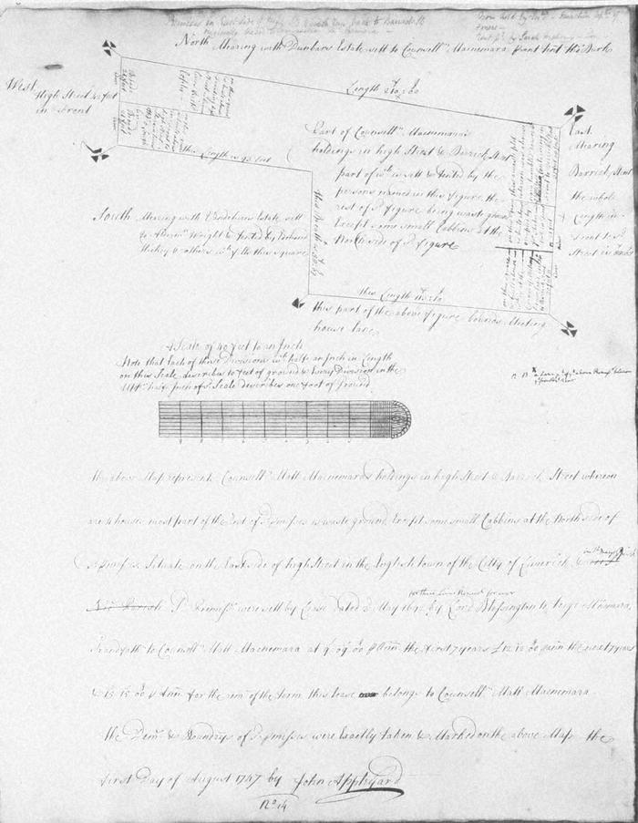
Map, photograph of, from set of estate of Edward Hoare in the city of Limerick by John Appleyard, 1747. No. 14. Premises fronting onto E side of High St, backing onto Barrack Street, bounded on S by Meeting House Lane. St Nicholas parish crossed out and replaced with St Mary's. 1 August 1747. Counsellor Matthew MacNamara's holding, set by Lord Blessington in 1692 to Teige McNamara grandfather of present holder. mears on west with High Street, on north with the Dunbar estate set to Counsellor McNamara and tenanted by Thomas Burke; on the east with Barrack Street, ; and on the south in part with meeting House lane and part with the Vandeleur estate set to Alderman Wright and tenanted by Edmond Hickey. Pencil note that now held by executors of Inichin and rent paid by Sarah Mahony
(see also Limerick City Archive; Series 2: Volume 1: P23/ 25-47, 1874-1908 File 10: Particulars and Conditions of Sale by Auction of the Hoare Estate, including property in Mungret Street, Mary Street, Bridge Street, Nicholas Street, Castle Street, The Crescent and Henry Street, Limerick; includes hand coloured maps by R. Fogerty. William B. Fitt Auctioneers., 27 February 1903 )
(see also Limerick City Archive; Series 2: Volume 1: P23/ 25-47, 1874-1908 File 10: Particulars and Conditions of Sale by Auction of the Hoare Estate, including property in Mungret Street, Mary Street, Bridge Street, Nicholas Street, Castle Street, The Crescent and Henry Street, Limerick; includes hand coloured maps by R. Fogerty. William B. Fitt Auctioneers., 27 February 1903 )
John Appleyard (surveyor)