Map
Collection object
1987.0162.13
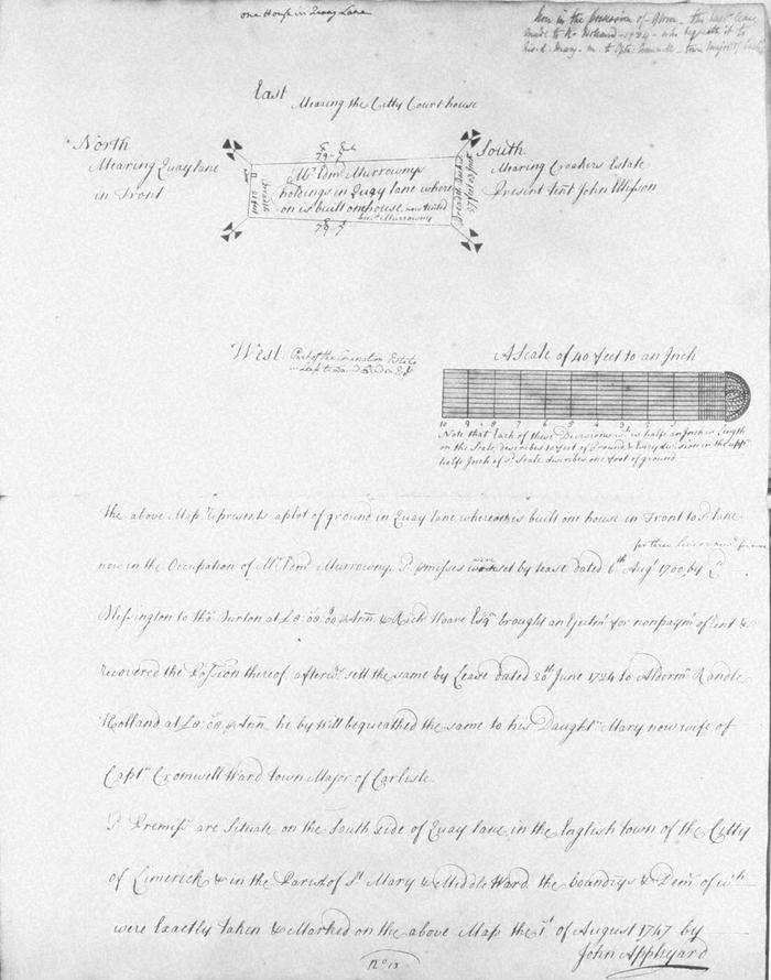
Map, photograph of, from set of estate of Edward Hoare in the city of Limerick by John Appleyard, 1747. No. 13. Premises fronting onto S side of Quay Lane, bounded on E by the city court house, St Mary's parish, Englishtown. 1 August 1747. House occupied by Edmund Murrowny (Morony). let by Lord Blessington in 1700 to Thomas Burton who was ejected for non payment and so went to Richard Hoare who let to Aldeman Randle (Randal) Holland who bequeathed it to his daughter Mary now wife of Captn Cromwell Ward, town major of Carlisle. Mearing on the east with the City courthouse, on north with Quay lane, on south with part of Corporation estate leased to David Bindon and on south with the Corker estate, tenanted by John Wilson. Pencil note at top right unclear, now in the possesision of ?Obrien?
(see also Limerick City Archive; Series 2: Volume 1: P23/ 25-47, 1874-1908 File 10: Particulars and Conditions of Sale by Auction of the Hoare Estate, including property in Mungret Street, Mary Street, Bridge Street, Nicholas Street, Castle Street, The Crescent and Henry Street, Limerick; includes hand coloured maps by R. Fogerty. William B. Fitt Auctioneers., 27 February 1903 )
(see also Limerick City Archive; Series 2: Volume 1: P23/ 25-47, 1874-1908 File 10: Particulars and Conditions of Sale by Auction of the Hoare Estate, including property in Mungret Street, Mary Street, Bridge Street, Nicholas Street, Castle Street, The Crescent and Henry Street, Limerick; includes hand coloured maps by R. Fogerty. William B. Fitt Auctioneers., 27 February 1903 )
John Appleyard (surveyor)