Map
Collection object
1987.0162.01
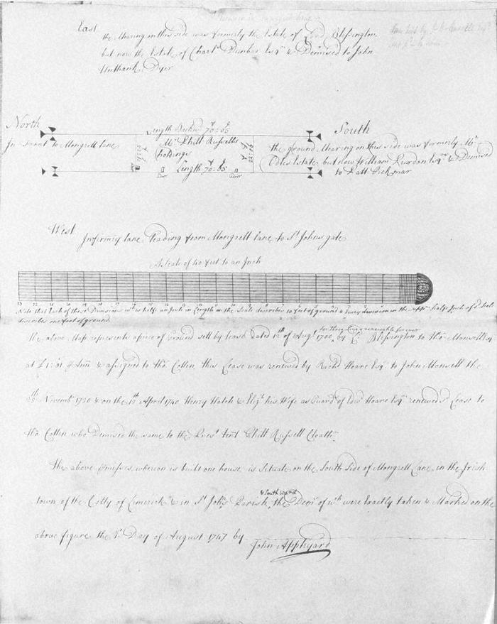
Map, photograph of, from set of estate of Edward Hoare in the city of Limerick by John Appleyard, 1747. No. 1. Premises in Mungret Lane, S side. 1 August 1747. Ground set by lease of 12th August 1700 by Lord Blessington to Thomas Monsell and assigned to Thomas Cotter,; lease renewed by Richard Hoare to Thomas Monsell on 25th Nov 1720, and on on 12th April 1740 henry Hatch and Elizabeth his wife as Guardians of Edward Hoare renewed lease to Thomas Cotter who demised it to the present tenant Phillip Russel, Cloathm. (Clothier/cloth merchant?) Fronting on north to Mungret Lane, west to Infirmary Lane; on south mearing with what was Mr Odle's (Odell?) estate but now William Purdon demised to Batt Pickman; on east formerly the estate of Lord Blessington, now estate of Charles Dunbar and demised to John Unthank, dyer. Comment to right of last that now held by John Russell.
(see also Limerick City Archive; Series 2: Volume 1: P23/ 25-47, 1874-1908 File 10: Particulars and Conditions of Sale by Auction of the Hoare Estate, including property in Mungret Street, Mary Street, Bridge Street, Nicholas Street, Castle Street, The Crescent and Henry Street, Limerick; includes hand coloured maps by R. Fogerty. William B. Fitt Auctioneers., 27 February 1903.)
(see also Limerick City Archive; Series 2: Volume 1: P23/ 25-47, 1874-1908 File 10: Particulars and Conditions of Sale by Auction of the Hoare Estate, including property in Mungret Street, Mary Street, Bridge Street, Nicholas Street, Castle Street, The Crescent and Henry Street, Limerick; includes hand coloured maps by R. Fogerty. William B. Fitt Auctioneers., 27 February 1903.)
John Appleyard (surveyor)