Map
Collection object
1987.0148
Map sheet edges L. 51.2 x W. 46.6
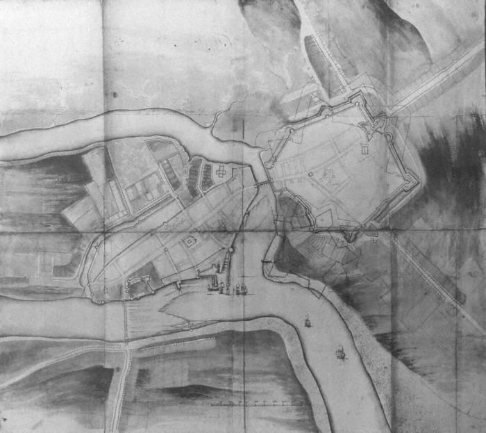
Map, photograph of, framed. Plan of The Citty of Limricke(centre, on city), c. 1685. Also of The Irish Towne (centre of Irishtown). National Library Ms. 3137/25, negative no. 20198. View of layout, fortifications of city and Irishtown, waterways and something of topography of surrounding area. Also outlines of proposed? or suggested? defensive works in and about Irishtown. No legend. Sailing ships are shown sailing up to and at the city, outside the watergate, one ship is shown docked inside the sheltered area, and several smaller vessels are shown docked also. Bottom, centre, a scale in feet, from 0 to 1000, increasing in increments of 100 feet, and Thomas Philips signature underneath. The following buildings shown: St. Munchins Church, Thomond gate, bridge and bridge tower, King John's Castle, St. Mary's Cathedral, The Water Gate and docks area, New Gate and associated walls, Franciscan Church, Thomcore, St. John's Irishtown (An Abby), as well as the perimeter walls and towers of both halves of Limerick. Note the mills shown in the Shannon and Abbey rivers. Also note streetscape developing outside the walls. Finally note what might be the depiction of a wrecked ship on the Irishtown side of the Abbey river.
Thomas Phillips (mapmaker)