Map
Collection object
1990.0196
Photo H. 14.5 W. 51.5 Mount H. 23.4 W. 58.4
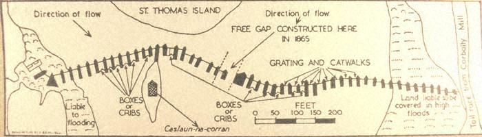
Photo, black and white, matt. Photographic copy of a plan of the Lax-weir; inscribed in corner "Based on plan by A. Gray-1864". Shows the layout of the weir at the tip of St. Thomas Island, with arrows pointing to "Boxes or cribs", "grating and catwalks", "Free gap constructed here 1865" and "Caslaun-na corran" with direction of flow arrows as well. At either end of the weir is marked land liable to flooding and at right of map is the tail race from Corbally Mill. Mounted onto beige card.
A Gray (mapmaker)